World Map, GreedFall Map

World Map

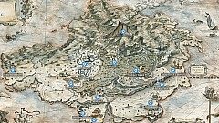
The map of The Island of Teer Fradee. Subzones: Sérène, New Sérène, San-Matheus, Anemhaid - "The Fiery Soul", Dorgred - "The Heart's Gates", Glendgnámvár - "The Shore of the Tall Bones", Magasvár - "The Vale of the Great Battle", Steiger falág - "The Rocky Steps", Tír dob - "The Black Lands", Vedrad - "The Red Woods", Védvílvie, Wenshaganaw - "The Singing Waters", Cwenvár - "The Tall Trees", Meinei falág - "The Rocky Mounts".

Markers on the map
  • Subzones16
Sérène, GreedFall Map

Sérène

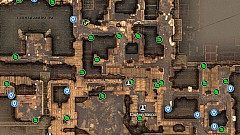
Map of the entire city of Sérène, the starting area where the GreedFall prologue takes place. Quests, NPCs, enemies, interesting locations, places where the loot can be found, and other points of interest.

Markers on the map
  • NPCs6
  • Other location1
  • Entrances16
  • Enemies4
  • Chests7
  • Barrel1
  • Crates37
  • Other2

New Sérène

The city of New Serene was founded around 5 years ago by Madame de Morange on the site of a small fort built by the Congregation shortly before. Ideally located in a cove where boats can anchor easily and halfway from cities on the two other nations of the island continent, this young city is constantly growing and teeming with new settlers.

Markers on the map
  • Entrances5
  • NPCs4
  • Location1
  • Travel4
  • Caravan2
  • Passages4
  • Enemies3
  • Ore8
  • Herbs10
  • Mushrooms9
  • + more73

Glendgnámvár

Glendgnámvár is a coastal region bordered by high granite cliffs located southeast of Teer Fradee. Whales sometimes approach, and their bones gave it its native name: the "Shore of the Tall bones".

Markers on the map
  • Merchant1
  • Professor Serafeddin's Notes4
  • Skill altars2
  • Campsites4
  • Locations2
  • Entrances6
  • Passages3
  • Chests7
  • Travel4
  • Caravan1
  • + more18

Vedrad

Vedrad is a forested area north of New Serene. The species of trees with flaming foliage in this forest are probably at the origin of its native name: "the red woods".

Markers on the map
  • Professor Serafeddin's Notes1
  • Skill Altars2
  • Campsites4
  • Locations6
  • Entrances8
  • Passages7
  • Travel5
  • Herbs26
  • Ore3
  • Crates6
  • + more52

Magasvár

Magasvár is a region with varied landscapes, rocky in the North and East, and marshy in the West. The ancient ruins which witnessed legendary clashes gave it its native name: the "Valley of great combat".

Markers on the map
  • Professor Serafeddin's Notes3
  • Skill Altars3
  • Campsites5
  • Location1
  • Entrances7
  • Chests7
  • Enemies10
  • Travel5
  • Herbs2
  • Other5

Wenshaganaw

Wenshaganaw is a coastal region crossed by a river. The local inhabitants, very in touch with the sea and the water, named it "the singing waters" for this reason.

Markers on the map
  • Campsites3
  • Skill altars3
  • Travel4
  • Other10

Region of Hikmet

The Hikmet area is on the east side of the island, where at the mouth of a river the settlers of the Bridge Alliance set foot on Teer Fradee for the first time and founded their city.

Markers on the map
  • Campsites3
  • NPCs2
  • Locations2
  • Enemies11
  • Passages2
  • Travel2
  • Caravan1
  • Chests10
  • Crates4
  • Herbs33
  • + more12

San Matheus

The region of San Matheus lies to the west of Teer Fradee. Thélème built its city in a cove to anchor ships, and as far as possible from the city of their enemies of the Bridge Alliance.

Markers on the map
  • NPCs4
  • Entrances13
  • De Sardet Residence1
  • Merchant1
  • Crafting Table1
  • Campsites2
  • Caravan1
  • Travel2

Frasoneigad

Frasoneigad is a particularly wild forest area inhabited only by the most isolationist natives, or by those who want to hide. They named it the "forest of the ancients" because of the venerable age of the trees found there.

Markers on the map
  • NPC1
  • Skill altars2
  • Campsites5
  • Entrances6
  • Travel2
  • Other26

Tír dob

Tír dob is a region whose land in many places still bears the mark of the terrible fire that ravaged it; this dark colour is at the origin of its name "the black lands".

Markers on the map
  • NPC1
  • Skill altar1
  • Campsites3
  • Location1
  • Entrances7
  • Travel5

Védvílvie

Although few natives live in these swamps, Vedvílvie is a region inhabited by many animals and wild creatures, which are the origin of its name: the "swamp of a thousand lives".

Markers on the map
  • Entrance1
  • Campsites3
  • Travel1

Steiger falág

Steiger falág is a rocky region at the foot of the mountain range dominated by the huge volcano in the heart of the island.

Markers on the map
  • Professor Serafeddin's Notes1
  • Skill altar1
  • Campsites2
  • Entrances2
  • Travel3
  • Enemies6
  • Crate1
  • Other1

Meinei falág

Meinei falág is a steep area on the slopes of the mountain that gave it its name: the "rocky mountains".

Markers on the map
  • Campsite1
  • Travel1

Dorgred

Dorgred is a small area that lies around a mountain lake and is located near the main sanctuary of Teer Fradee, which gave it its name: the "doors of the heart".

Markers on the map
  • Other8

Cwenvár

Cwenvár is a forested and rather isolated valley whose tall trees are particularly popular with carpenters from the mainland and are the source of its native name.

Markers on the map
  • Entrance1
  • Campsites4
  • Travel2

Anemhaid

This small region is accessible only to the kings and queens of Teer Fradee or those willing to pass the many trials that grant access to the sanctuary hidden in the heart of the volcano.

Markers on the map
  • Entrance1
  • Campsite1
  • Crafting Table1
  • Travel1